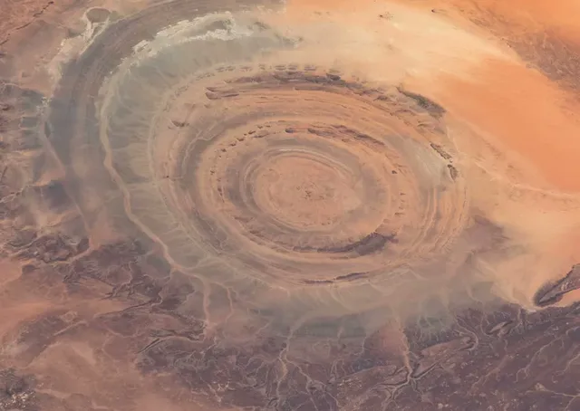
Madar (Nouakchott) - The Richat Structure, known worldwide as the "Eye of the Sahara", is back in the spotlight after a feature published by the British magazine Discover Wildlife on Sunday, October 18, 2026, describing it as visible from space, the size of London and rumoured to be the lost city of Atlantis, "but the truth is far stranger".
Located on the Adrar plateau, it is made up of concentric rings of rock about 40 km across, so vast that someone standing inside would not realise they were in a circle, the magazine said.
From space to the lab
Mapped by French geographers in the 1930s, it became world-famous in 1965 when US astronauts Ed White and James McDivitt photographed it during the Gemini IV mission.
In 1948 geographer Jacques Richard-Molard suggested it was formed by rising magma; in 1952 naturalist Theodore Monod found three nearby impact craters (Aouelloul, Temimichat-Ghallaman and Tenoumer), leading many to think it was a crater too, until US geologist Robert Fudali showed in 1969 that it was not.
A 2005 study in the journal Geology concluded it is an eroded geological dome: molten rock pushed the layers up, then sand and wind carved the rings, leaving the oldest rocks at the centre. Its age is still debated, but it predates humans by tens of millions of years.
Atlantis, a myth without support
Some link it to the Atlantis described by Plato around 360 BCE, but geologists easily dismiss the idea given its age, and nothing resembling Atlantis has been found there, according to the magazine.
The site does hold traces of early humans: Acheulean stone tools attributed to Homo erectus and Homo heidelbergensis, mostly in the outer ring, Neolithic spear points and stone burial mounds that have yet to be excavated.